Printing a Map |
  
|
Printing a Map |
|
The print map function does not directly send a map to your printer. Rather the print map tool creates an image in JPEG or PDF format (see the compatibility section to obtain a free PDF viewer) that can be printed or saved. When printing a map you have the option to "Preserve Scale". By preserving the scale the extent of the map and features shown may change due to the differences in size and resolution between your monitor and the PDF size. If you would prefer keep the map extent un-check the "Preserve Scale" option.
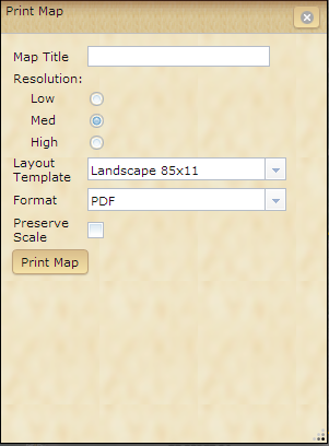
1.Click the Print Map button![]() ; a dialog box will open.
; a dialog box will open.
2.Type in a Map Title for your map.
3.Choose an image resolution
4.Choose a layout template and format. If using the "Map Only" option you be asked to choose a height and width in pixels. The "Map Only" option does not contain layout information.
5.Click Print Map. The map image is ready to be saved or printed.